
This content is copyright to www.artemis.bm and should not appear anywhere else, or an infringement has occurred.
Hurricane Beryl is back, having regained its hurricane strength wind speeds and now the storm heads for a Texas landfall. The fact Beryl took longer than anticipated to regain its structure and intensify again over the Gulf has likely saved the State from a more impactful catastrophe event.
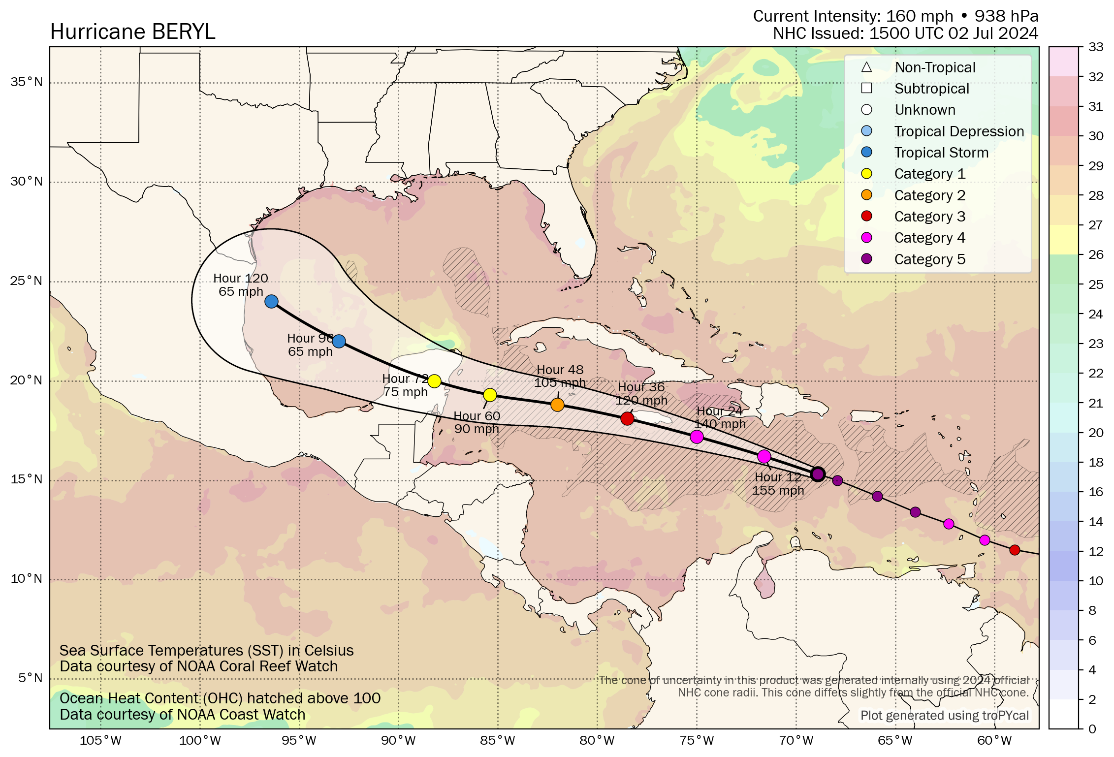
We continue to update this article, which we leave mostly intact for you to view below, including comments on Mexico, the IBRD catastrophe bonds and Beryl’s struggle to regain its form.
To skip to the latest from Monday 8th July, click here.
09:00 UTC, Friday update: Hurricane Beryl continues to defy the models to a degree, having failed to weaken as much as had been anticipated and strengthened faster through almost its entire life so far, once again the hurricane has intensified back to major Category 3 strength as it approaches landfall on Mexico’s Yucatan peninsula.
A few days ago, the forecasts were calling for Beryl to be a weakening Category 1 hurricane at landfall on Mexico’s Yucatan Caribbean coast.
But, the models have steadily intensified their forecasts and Beryl has also shifted track a little north, with it now set for landfall somewhere along the coast in the region of Tulum, Quintana Roo.
The weakening expected has not occurred and in fact overnight what was a Category 2 hurricane Beryl has intensified again to Category 3, with winds of 115 mph.
Hurricane Beryl’s minimum central pressure had risen to 974mb by midnight UTC time, but then the NHC put out an update cutting 12mb off that and said Beryl had re-intensified to Category 3 with minimum central pressure of 962mb at the time.
At the latest update, hurricane Beryl’s minimum central pressure is pegged back up at 971mb after a reconnaissance aircraft mission, which is expected to rise a little further by landfall in a few hours time.
The entire coastline from south of Tulum up to Cozumel and as far north as Cancun is facing hurricane and tropical storm force winds, but hurricane Beryl’s core has tightened, with hurricane winds now only extending outwards 30 miles from the center, tropical storm force winds extending 140 miles out.
Winds will be most damaging where Beryl’s eye comes ashore, but storm surge is also set to be an issue with heights of up to 6 feet expected as well as rainfall of up to 10 inches.
As a reminder, Mexico has a World Bank facilitated catastrophe bond in-force, which it renewed in April.
Mexico’s government secured $125 million of cover from the Class C notes issued with the IBRD CAR Mexico 2024 cat bond issuance, which is the layer of protection exposed to hurricane Beryl.
This parametric catastrophe bond features a trigger design that has zones along the Atlantic coastline and depending on where a hurricane comes ashore, it must have a central pressure low enough to breach that particular trigger zone and activate the insurance coverage for Mexico.
But, the central pressure needs to be 950mb or lower for Mexico’s IBRD parametric cat bond to face even a 25% loss of principal and in the region of the Yucatan where hurricane Beryl is heading, we’re told it would actually need to be lower still, below 935mb it seems.
So, even though hurricane Beryl intensified back to Category 3 strength and its central pressure dropped somewhat, it is still far too high for Mexico’s parametric catastrophe bond to be threatened.
It’s worth noting though, that Mexico’s tourism industry has been a purchaser of parametric insurance over the years, with some resort owners buying hurricane protection in parametric form.
So, there is the potential for some parametric exposure along Mexico’s Yucatan coastline, being an area with high levels of tourism and many expensive resorts.
Beyond that, the broader insurance and reinsurance market exposure from hurricanes on Mexico’s Atlantic coastline is not typically thought to be significant, with losses typically within reinsurance risk appetites from storms that impact the region.
But, for the people of the Yucatan in the path of major hurricane Beryl, a challenging few hours are ahead and all thoughts are for people’s safety as the storm passes.
Further ahead, hurricane Beryl is set to weaken over the Yucatan and the emerge into the Gulf of Mexico, where uncertainty is the name of the game once again.
Forecast models differ still, with some pointing to a north Mexico landfall as a strong tropical storm or weak hurricane, others opting for the Mexico-Texas border region and a weakish hurricane, but still other forecast models are further north and east, with a stronger hurricane landfall forecast for Texas’ Gulf Coast.
While the model mean aims for the border region right now, meteorologists have been discussing a northward shift and the potential for that to continue, bringing hurricane Beryl further into Texas. There has also been some talk about a potential stalling and turn on approach, which could mean impacts on the Texas coast for longer and torrential rainfall.
Update – 16:00 UTC: New forecast updates from the NHC have shifted the path for Beryl sufficiently to show a Texas landfall very near to the border, at mid-Category 1 hurricane strength. Almost every model we’ve checked now favours Texas at Category 1 or even 2 strength, with a landfall late Sunday into Monday somewhere between the border and Corpus Christie seeming the current range. But, as the image below shows, a curve further east cannot be discounted still, given the way the forecast cone develops as it reaches the Gulf Coast.
With the Gulf of Mexico still plenty warm enough to sustain and intensify a hurricane, how long hurricane Beryl spends over it and what track it takes is critical to the eventual strength and any landfall outcome in the United States.
We likely won’t have a better view of how much of a threat this is to Texas until after Beryl’s passage across the Yucatan, so by later tonight, to see whether that severely degrades the storms integrity and hinders its ability to intensify again over the Gulf.
At this time 16:00 UTC, the NHC says Beryl remains a hurricane, with sustained winds of 85 mph and a central pressure of 980mb.
Meteorologists are concerned that Beryl’s northwards movement has been missed by many of the models, which correct and catch up with their updates. But those plotting satellite and radar imagery of Beryl versus the model runs are all noting how it has moved more north, while also sustaining more intensity than the model forecasts had suggested.
As said, the eventual destination of hurricane Beryl and any landfall location in Texas, or Mexico if it fails to turn, remains highly uncertain.
But we’re now seeing some meteorologists warning of a set up that could allow for potentially rapid intensification, while others are saying if the storm turns east as it nears the Gulf Coast it could spend longer over very warm water and intensify right up to landfall.
Rainfall is another concern, as Texas had been soaked just in the last weeks, and hurricane Beryl will bring a lot of moisture with it.
BMS Re’s Senior Meteorologist Andrew Siffert has just published a further update at around 16:30 UTC Friday, warning in a Linkedin post of the potential for Beryl to rapidly intensify as it heads for Texas and saying, “The insurance industry should now expect an impactful event, especially on the north side of the center of and circulation, and should prepare a hurricane response early next week.
“The potential impact of Hurricane Beryl on the insurance industry, particularly on the north side of the center of circulation, should not be underestimated, and early preparation is advised.”
Update – 09:00 UTC – Saturday, July 6th:
Overnight, Beryl weakened back to tropical storm strength as a combination of its passage over the Yucatan and dry air getting into its core broke the storm structure down somewhat.
As of its 09:00 UTC update, the NHC put Beryl’s sustained winds at 60 mph and central pressure at 1001mb, but the forecast continues to call for intensification and for Beryl to regain hurricane strength as it moves across the Gulf of Mexico towards Texas.
The NHC said, “Beryl is moving toward the west-northwest near 12 mph (19 km/h). A turn to the northwest is expected later today and then north-northwestward by Sunday night. On the forecast track, the center of Beryl is expected to approach the Texas coast by late Sunday into Monday morning.
“Maximum sustained winds are near 60 mph (95 km/h) with higher gusts. Little change in strength is expected today, but strengthening is expected to begin by Sunday, and Beryl is forecast to become a hurricane before it reaches the Texas coast. Tropical-storm-force winds extend outward up to 115 miles (185 km) from the center.”
The NHC’s forecast suggests a track into Texas somewhere to the east of Corpus Christi. The track has again moved north and east and it will need to be watched for further movement in that direction, which could bring a hurricane Beryl closer to Galveston and Houston, both of which are in the forecast cone.
With intensification set to be slow at first, as Beryl regains some structure, it could be another half day or so before the forecasts give a better idea of wind speeds at landfall. Right now the forecast advisory suggests intensification right up to landfall, with sustained winds of just above 90 mph currently expected when Beryl is on the Texas coast, with gusts of 115 mph.
The latest NHC warnings call for a storm surge of up to 5 feet, but that is likely to rise as Beryl regains hurricane strength, with the only question now being how fast and how far it can intensify again, giving it longer over the warm Gulf waters, and whether any further entrainment of dry air could hinder the storms progress.
As of a 12:00 UTC update from the NHC on Saturday, July 6th, Beryl is still a tropical storm with 60 mph sustained winds but slightly lower pressure at 999mb, and the NHC continues to state that it expects Beryl will be a hurricane again by landfall on the Texas coast.
Hurricane hunter aircraft are investigating Beryl at this time, so a better idea of the pressure and any intensification may be available after that analysis is complete.
At the 15:00 UTC update not much has changed and Beryl is still a tropical storm with winds of 60 mph, but a central pressure again slightly lower at 997mb.
Meteorologists say there are signs of more convection around Beryl’s center, which suggests some intensification is occurring and some are saying Beryl may be outpacing the models again at this time.
The landfall forecasts remains for a strong Category 1 hurricane at this time, somewhere on the central Texas coastline by late Sunday or early Monday.
Update – 08:00 UTC – Sunday, July 7th:
Beryl continues to head towards Texas but has been slower to intensify than many expected, as continued influence from wind shear and dry air has hindered its ability to recreate the eye wall it once had.
Despite this, all forecast models call for intensification over the next day as Beryl approaches the central Texas coast, with most calling for a mid to high Category 1 hurricane Beryl landfall early on Monday local time.
The latest NHC forecast from 06:00 UTC puts Beryl’s sustained winds at 60 mph still, but with a slightly lower again central pressure of 995mb.
The NHC noted, “Strengthening is expected, and Beryl is forecast to become a hurricane again later today or tonight before it reaches the Texas coast.”
Some forecast models deepen hurricane Beryl to what could be Category 2 before landfall, but the storm is certainly diminished in size and so wind damage would be anticipated mainly to the east of the landfall region and mostly concentrated where the strongest winds were, if the storm can regain a more damaging level of intensity.
However, as time passes and it takes longer for Beryl to regain form, more of the models are now opting for a strong tropical storm landfall instead. But, it’s important to note that some meteorologists continue to caution that a period of more rapid intensification is possible, as wind shear is expected to subside and Beryl will be passing over very warm Gulf Coast waters.
Hence, there seems a considerable amount of uncertainty still, in just how strong Beryl could become. But, as we reported Saturday evening, even at high Category 1 strength, the impact to the reinsurance market from Beryl is not expected to be significant.
The forecasts for storm surge have risen a little as the storm nears the Gulf Coast, with heights of 4 to 6 foot now anticipated for the Texas coastline from Mesquite Bay to Freeport, and for Matagorda Bay.
Corpus Christi and Galveston are forecast for storm surge of 3 to 5 feet.
Localised rainfall of up to 15 inches is anticipated, but it’s important to note that Beryl, whether a hurricane or not, is expected to travel inland relatively quickly, so based on the forecast it is not expected to stall on the coast like Harvey did in 2017. As a result, flood damages are possible, but not of the scale seen back then.
The NHC forecast advisory from 03:00 UTC has a Category 1 hurricane Beryl with sustained winds of around 86 mph at the time it makes landfall on the Texas coast.
A later 09:00 UTC update from the NHC has not changed Beryl’s intensity, keeping the storm at 60 mph sustained winds, with a central pressure of 995mb.
A further NHC update at 12:00 UTC still has Beryl as a tropical storm with 60 mph sustained winds, but the central pressure has been lowered slightly further to 992mb, based on new dropsonde data from reconnaissance aircraft.
The NHC said that Beryl is still expected to become a hurricane before landfall.
At 15:00 UTC on Sunday Beryl has begun to intensify, with sustained winds now estimated at 65 mph and a central pressure still at 992mb.
The NHC noted that “Beryl is becoming better organised” and is expected to intensify to a hurricane before landfall in Texas.
In an update on Sunday 7th Andrew Siffert of reinsurance broker BMS Re explained that after a further review of model data, “It would appear that overall insured loss will likely be sub $500M if Beryl makes landfall in the expected rural areas between Freeport, Texas, and Rockport, Texas, as a category 1 hurricane.
“This means the event will likely be a retained event for most insurance carriers and have little to no impact on the reinsurance industry.
“The worst storm impacts on the current expected track should fall between Port O’Connor and Freeport, Texas. Beryl should cause light damage, power disruptions, and down trees but is not likely to be near catastrophic. The biggest risks are waves and storm surge flooding on the coast and river and flash flooding inland near Houston.”
Meanwhile, Aon’s Impact Forecasting team cautioned in an update that, “While there are no changes to the intensity forecast based on the latest guidance, we are expecting Beryl to be intensifying up until landfall early Monday, and people should be preparing for the possibility of a category 2 hurricane landfall.”
So there is still some uncertainty, but given how near to landfall Beryl now is, it is hard to see it strengthening much further than Aon’s suggestion above, meaning reinsurance sector losses should be relatively limited.
Update – 04:00 UTC – Monday, July 8th:
Beryl is a hurricane again, as data from the Houston doppler radar and reports from hurricane hunter aircraft confirm that hurricane Beryl now has sustained winds of 75 mph and higher gusts.
The NHC said that, “Additional strengthening is expected before landfall on the Texas coast”
Hurricane Beryl’s minimum central pressure is 985 mb.
It has taken longer than most forecasters anticipated for Beryl to regain hurricane strength, which has saved the Texas coast from a more powerful storm it now seems. Dry air entrainment hindered the west side of Beryl as it reorganised, but still threats remain to those in the path of the storm and Beryl will bring impacts to some areas.
For the insurance and reinsurance industry, this continues to look like an event that will be largely retained at the primary level of the market, with no meaningful impact for reinsurance capital.
You can see the latest forecast and position from Tomer Burg’s map below (click for the latest version):
Meteorologists say that Texas may have avoided a far more impactful storm, as had the dry air entrainment not hindered Beryl’s progress, the storm could have been a more significant hurricane by this time.
Also, Beryl’s track has continued to shift a little north and east, bringing higher areas of insured exposure closer to the cone, where a more significant hurricane could have resulted in greater damages.
As it is Beryl remains a low Category 1 at this time, but the hurricane is expected to intensify a little more by landfall.
Storm surge warnings have now risen to up to 7 feet, for Port O’Connor to San Luis Pass and Matagorda Bay, with 4 to 6 foot of surge expected for Galveston Bay.
Rainfall amounts of as much as 15 inches are anticipated in localised areas, with more broadly 5 to 10 inches possible. As a result, flooding is a concern for some areas that have been soaked in recent days.
As of an 06:00 UTC update on Monday, the NHC now puts hurricane Beryl’s sustained winds at 80 mph with higher gusts.
The NHC noted that, “Beryl is strengthening as the center nears the middle Texas coast.”
Central pressure is down to 982 mb and additional strengthening is expected, the NHC said, while tropical-storm-force winds extend outward up to 115 miles from the center of hurricane Beryl.
At 09:00 UTC the center of hurricane Beryl made landfall near Matagorda, Texas as a Category 1 storm with sustained winds of 80 mph and a minimum central pressure of 979 mb.
Track the 2024 Atlantic tropical storm and hurricane season on our dedicated page and we’ll update you as new information emerges.
Beryl becomes a hurricane again, heads for Texas landfall was published by: www.Artemis.bm
Our catastrophe bond deal directory
Sign up for our free weekly email newsletter here.

